
1. Why long-range forecasts matter for riders
Long-range seasonal forecasts give you a broader picture than day-by-day weather models: they highlight whether the season is likely to be colder/warmer or snowier/drier than normal across regions. For skiers and snowboarders planning a trip between Nagano and Hokkaido, these signals help choose timing, target resorts, and risk-management strategies for travel and accommodation.
2. Key meteorological drivers — the foundation of this outlook
This seasonal forecast relies on several large-scale climate factors that strongly influence East Asia’s winter weather:
- ENSO (El Niño / La Niña): Sea surface temperature anomalies in the tropical Pacific change atmospheric circulation. La Niña tendencies generally favor more frequent cold outbreaks over East Asia and enhanced moisture influx off the Sea of Japan, which can increase Japan Sea–side snowfall.
- Arctic Oscillation (AO) / North Atlantic / Siberian patterns: Phases of the AO and related wave patterns control how far cold Arctic air plunges south. Negative AO (or favorable blocking patterns) often increases the chance of large cold outbreaks reaching Japan.
- Orographic forcing: Japan’s coastal mountains force moist air upward, producing heavy terrain-induced (orographic) snowfall on the windward slopes — a local but decisive factor for individual resorts.
(Forecasts referenced here are based on seasonal model consensus and climate indicators such as ENSO outlooks and typical historical relationships. Seasonal projections always carry uncertainty and are subject to updates as new observations arrive.)
3. Seasonal summary (overall expectation)
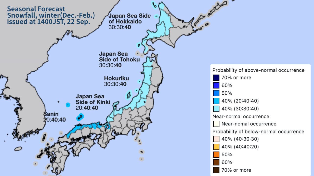
At present, model consensus and climate indicators point to a winter that is overall near-normal in temperature across most of Japan, with a tendency toward near-normal to slightly above-normal snowfall in Japan Sea–facing mountain ranges and parts of Hokkaido — especially in the early season (December–January) if La Niña–like influences hold. That said, the later season (February–March) may see increased variability as oceanic and atmospheric conditions evolve.
4. Regional outlook: Nagano → Hokkaido (detailed)
Nagano & the Japan Alps (Hakuba, Nozawa, Shiga, etc.)
Outlook: Multiple episodes of terrain-forced heavy snowfall are likely when strong northwest cold flows tap moisture from the Japan Sea. That makes mid-winter (Dec–Jan) promising for significant snowfall on the windward Alps. Valley and basin areas (e.g., Nagano city) remain more variable and may see less snow than the high slopes.
Why: If La Niña tendencies encourage persistent cold outbreaks and the Sea of Japan stays relatively warm, those conditions favor moist air override and orographic lift over the Alps — ideal for deep, dry powder at elevation.
Northern Honshu & Tohoku (mountain sectors)
Outlook: Snowfall chances are favorable on the Japan Sea side; inland and coastal exposure matters a lot. Backcountry and higher terrain should see solid accumulations during active cold episodes.
Hokkaido (Niseko, Rusutsu, Furano, Daisetsuzan)
Outlook: Hokkaido is expected to perform at least at near-normal snowfall levels, with particular strength on Sea of Japan–facing slopes (west/southwest Hokkaido) when storms form over the Japan Sea. Early to mid-season cold outbreaks can produce the driest, lightest powder (true “JAPOW”).
Why: Hokkaido’s geography — exposure to moisture off the Sea of Japan, combined with frequent cold air intrusions from Siberia — repeatedly creates the dry, low-moisture crystals that define premium powder. Local ocean temperatures and storm tracks will modulate totals, so watch storm frequency and origin.
Key uncertainties
- ENSO evolution: a shift toward neutral conditions later in winter could lower the frequency of strong cold outbreaks.
- AO / blocking: sudden changes in the Arctic Oscillation can produce unexpected cold snaps or milder stretches.
- Short-term storm tracks: a single persistent storm track can deliver season-changing totals to particular resorts while nearby areas remain quieter.
5. Rationale & evidence (how this forecast was reached)
The forecast combines several pieces of evidence common to seasonal meteorology:
- ENSO index patterns: Current indicators leaning toward La Niña–like or neutral conditions are historically correlated with more frequent Japan Sea storms and cold outbreaks in some winters.
- Sea surface temperature anomalies: Relatively warm Sea of Japan waters (compared to the adjacent air mass) increase moisture availability for snowfall when cold air blows over — strengthening terrain-forced precipitation.
- Upper-level circulation outlooks: Model ensembles indicating a higher likelihood of persistent northwest flow episodes favor orographic snow for windward slopes.
- Historical analogs: Past winters with similar ENSO / AO patterns often produced enhanced Japan Sea snowfall, especially in the first half of winter.
Note: seasonal forecasts are probabilistic. They communicate tendencies (more/less likely), not guaranteed daily weather. Always consult short-range forecasts and resort reports for trip-level decisions.
6. Practical tips for skiers & riders
- Target Japan Sea windward resorts during active northwest flow: When forecasts show strong northwest winds and a moist air source, move to Hakuba, Myoko, Niigata/Toyama slopes, or west Hokkaido (Niseko/Rusutsu) to chase heavy terrain-forced snow.
- Book flexible stays: If possible, leave at least one moveable block in your itinerary so you can jump on a powder window.
- Use real-time sources: Follow local snow reports, resort webcams, and hourly model outputs (e.g., hi-res NWP) in the 48–72 hour window.
- Prioritize elevation: Higher elevation often preserves drier powder, so prefer high-altitude runs on marginal snow days.
- Safety first: More snow can raise avalanche risk. If venturing off-piste, check avalanche bulletins, carry standard safety gear (transceiver, probe, shovel), and consider a local guide.
7. When to revise your plans — watch these signals
- Major updates to ENSO forecasts (clear move to El Niño or strong La Niña).
- Persistent positive/negative shift in the Arctic Oscillation.
- Marked warming or cooling of the Sea of Japan in early winter observations.
- Consecutive weeks of model consensus shifting the storm track east or west.
If you spot these changes in official forecasts, consider adjusting your target region or travel dates accordingly.