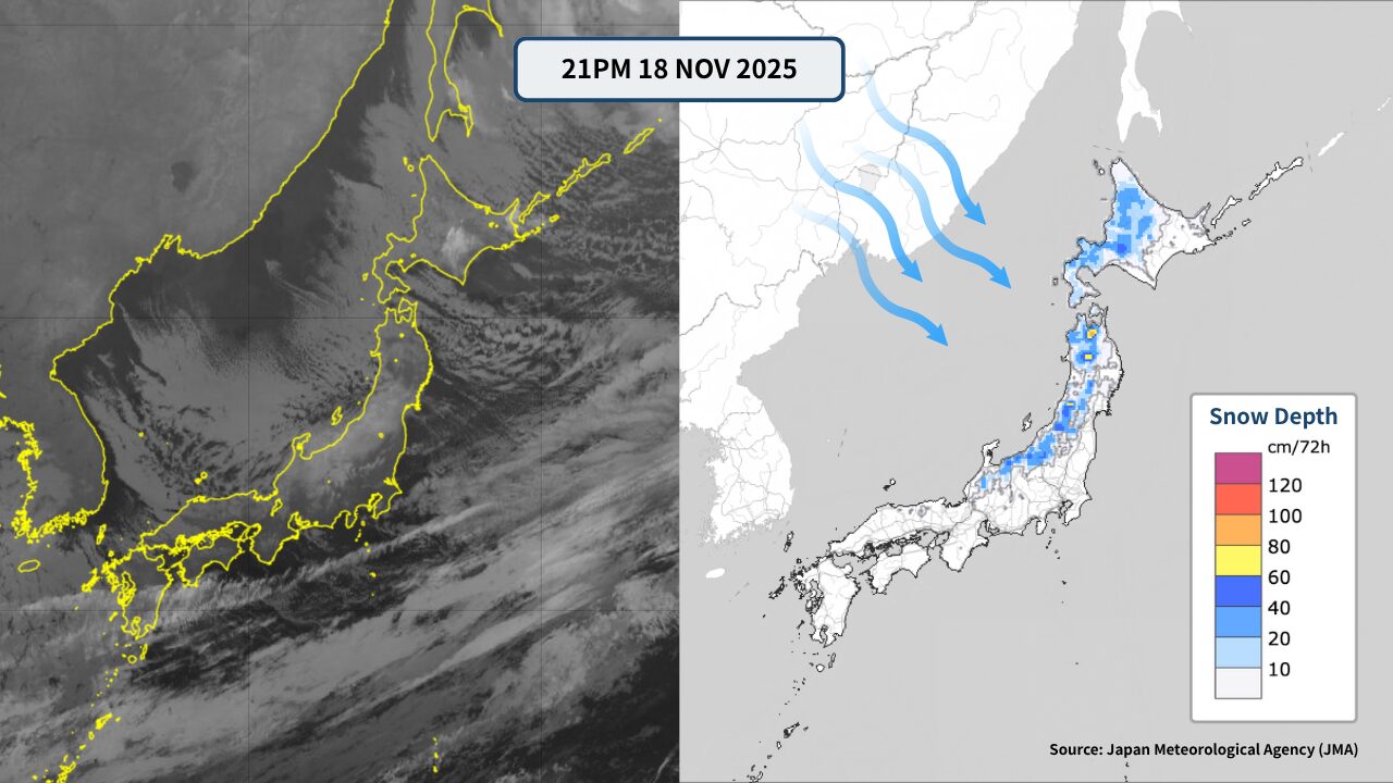
From around November 18, Japan is expected to shift into a strong winter-type pressure pattern again, bringing a rapid drop in temperatures. Significant snowfall is forecast mainly along the Japan Sea side, and the feel of the full winter season will become increasingly evident. Although much of Japan is still technically in autumn, the strong cold air expected this November will push the country quickly into winter conditions.
This article explains the outlook for skiers and snowboarders planning trips to Nagano, Niigata, Tohoku and Hokkaido: expected snowfall trends, likely snow depths, and practical cautions through the coming days and weekend.
1. Weather overview — strong cold air plunges into northern and central Japan; winter pattern strengthens
During the days following the 18th, colder-than-average air in the upper levels is expected to descend over Japan, producing a classic winter-type pressure pattern. Cloud bands over the Sea of Japan are spreading, and some northern areas may already observe very large snowfall over a 12-hour period (on the order of tens of centimeters in intense bursts).
- Widespread snowfall on the Japan Sea side
- Daytime temperatures remain low — near mid-winter levels
- Mountain areas may accumulate snow rapidly in short time spans
- Some regions can face wind-driven snow and blizzard-like conditions over the weekend
High-elevation ski areas can expect natural snowfall to increase, potentially expanding the number of skiable runs at resorts that have already opened.

2. Nagano Prefecture — heavier snow expected in the north; good conditions likely at Hakuba and Nozawa
Nagano will see strengthening snowfall from the 18th onward, especially in the northern districts.
Hakuba area (Happo, Tsugaike, Iwatake, etc.)
- Cold air impact is direct; intermittent snowfall is expected.
- Some days could bring 20–40 cm of new snow.
- High winds may occur at times, which could affect lift operations.
Upper-air forecasts for Hakuba (around 850 hPa / ~1500 m) indicate temperatures near −7 to −10°C — favorable conditions for snowfall and improvement of slope conditions for early-season openings.
Nozawa Onsen and Shiga Kogen area
- Mountain zones should see frequent snow.
- Shiga Kogen’s high elevation makes it likely to gain substantial snow depth.
- Powder days are possible over the weekend following the 18th.
Shiga Kogen, in particular, tends to build snow quickly when strong cold air arrives and may offer an early-season advantage for powder-seekers.
Karuizawa and lower-central resorts
Temperatures will fall, but snowfall amounts are generally lower than in the north. Artificial snowmaking will help stabilize conditions at many lower-elevation resorts.
3. Niigata Prefecture — Myoko and Joetsu likely to be hit hard; heavy snowfall possible
Niigata is one of the areas with the highest potential for heavy snow under this cold surge.
Myoko Kogen (Suginobara, Akakura, etc.)
- Moist air from the Sea of Japan will flow into the mountains, potentially causing heavy snow.
- From the 18th to the 20th, cumulative snowfall of roughly 30–60 cm in intense events is possible in some locations.
- Strong winds can bring whiteout conditions at times.
Myoko’s topography favors strong snow-band development; depending on the cold-air depth, snow types may range from heavy, wet snow to lighter powder.
Yuzawa, Naeba, and Kagura
Snow accumulation will increase in the mountain zones. Kagura’s higher elevations generally produce good snow quality. Yuzawa’s complex local topography can produce variable snowfall—temperatures rising briefly can yield wetter snow at lower elevations.
Coastal areas and Sado
Coastal zones may experience wind-driven snow and occasional ferry disruptions; however, coastal snowfall totals usually remain lower than mountain totals.
4. Tohoku — heavy snow possible in Yamagata / Fukushima / Iwate; Hachimantai and Appi prime powder targets
Wide areas of Tohoku are forecast to see snowfall from the 18th onward.
Yamagata (Zao, Gassan)
- Strong cold-air intrusions favor repeated snowfall; Zao may see a run-up toward the rime-ice / “juhyo” (snow monsters) season.
- High winds could create poor visibility in exposed areas.
Fukushima (Inawashiro, Grandeco)
Mountain areas will likely add snow rapidly; Grandeco is often rewarded with light snow that produces excellent powder on good days. Inawashiro’s totals depend strongly on where the snow bands set up.
Iwate (Appi, Hachimantai)
With favorable cold-air patterns, these northern Honshu resorts may see an elevated probability for powder days between the 18th and the 22nd — although strong winds in exposed zones warrant caution.
5. Hokkaido — widespread snow from central to southern areas; Niseko and Rusutsu likely to improve
Hokkaido experienced an early cold surge beginning on the night of the 17th; from the 18th onward, broad snowfall is expected across the island.
Niseko area (Grand, Annupuri, Village)
- Persistent snowfall is expected; summit areas may see very light, dry powder.
- High winds could lead to temporary lift closures at upper stations.
Rusutsu and Kiroro
Steady inflow of snow-clouds from the Sea of Japan is likely to support continuous snowfall. Kiroro typically accumulates stable early-season snow and often presents very good conditions.
Furano and Tomamu (inland)
Inland regions tend to be very cold; while total snowfall may be smaller than the Sea of Japan side, the snow is often very dry and excellent in quality. Temperatures may drop near −10°C on some days.
6. Practical advice for skiers & snowboarders
This winter-type pattern could mark the true start of the winter season in many regions. Keep the following points in mind when planning trips or heading out:
- Powder targets: Myoko, Hakuba, Niseko, Kiroro are likely top choices during this event.
- Stable conditions: Shiga Kogen, Kagura, Furano generally offer more stable snow due to higher elevation and colder temperatures.
- Wind risk: Be aware of lift operation notices at high-exposure sites such as Hakuba, Niseko and Zao where strong winds can halt upper-lift operations.
- Travel impacts: Expect possible chain/tyre restrictions on Expressways (e.g., Kan-etsu / Joshinetsu routes), road speed restrictions, whiteout conditions in Hokkaido, and possible ferry cancellations for coastal crossings during strong wind/snow events.
Summary
From November 18 a strong cold-air pattern will likely push many ski areas in Nagano, Niigata, Tohoku and Hokkaido into winter mode. Especially along the Japan Sea side, significant snowfall is expected and the chance to find early-season powder is rising. Please prepare for a sharp temperature drop, dress appropriately, and confirm lift operations and road conditions before traveling.
Stay safe and check the latest local forecasts and resort notices prior to heading out.


