
Due to the strong cold air mass that moved in last weekend, there was snowfall even in Nagoya, where I live.
In Nagoya, where it only snows a few days throughout the year, we still had snowfall, so ski resorts across Japan received widespread and substantial snow as well. As a result, the slopes are now in a condition where “a solid base (foundation) is in place, with light fresh snow on top,” making it an ideal timing to enjoy JAPOW right now.
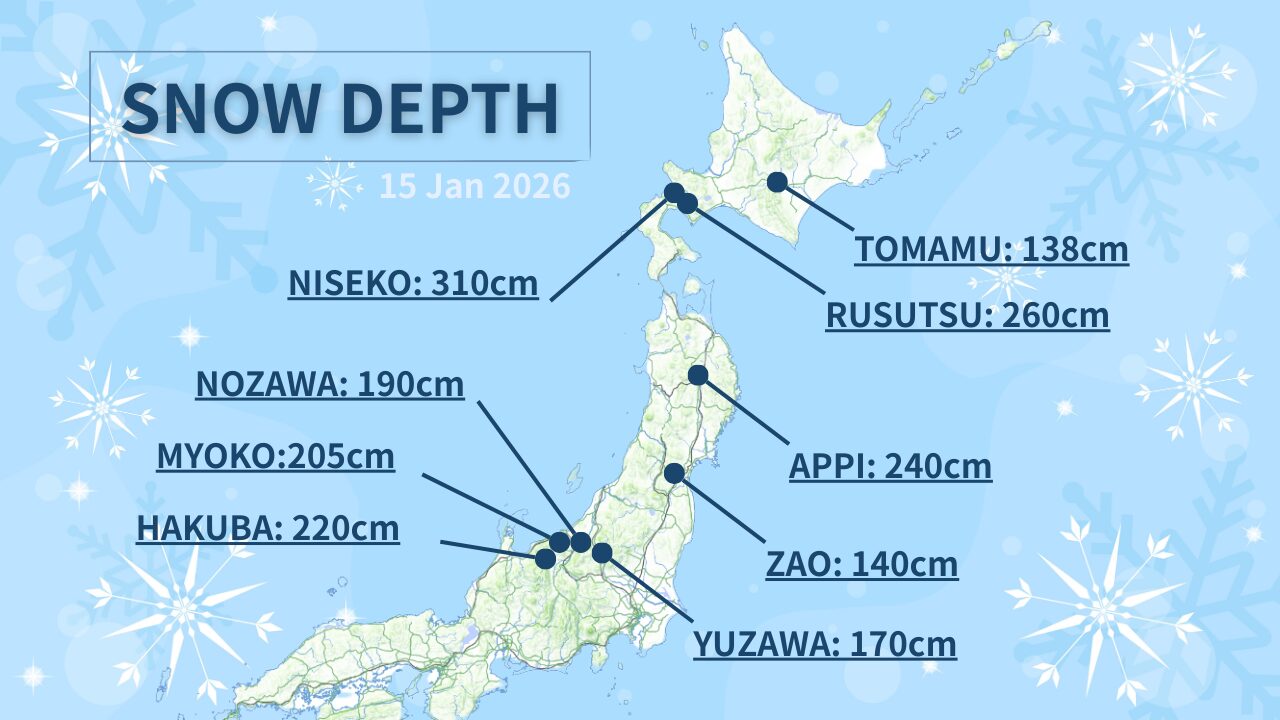
Of course, the amount of snow and how light it feels can vary depending on “elevation,” “wind direction,” “how the snow falls,” and “the observation point.” Here, to make it easy to understand for foreign skiers and snowboarders, we will use four areas—Hakuba, Myoko, Appi, and Niseko—as examples, and summarize the approximate snowfall since the weekend and what to expect going forward.
Hakuba (Hakuba) | The Base Is Complete Through “Added Accumulation.” Another Wave Is Also Expected
In the Hakuba area, the atmosphere changed all at once due to snowfall since last weekend. With fresh snow stacking on top of the existing snowpack, it has become a situation where “a satisfying depth” is likely to appear both on the runs and on the sides of the courses.
Fresh Snow Since the Weekend (Approximate)
- Over several days, a substantial amount of snow came in, and the entire area was solidly reset.
- The higher-elevation slopes tend to keep fresh snow more easily.
What to Expect Going Forward
- In the short term (a few days), even if there are periods when snowfall calms down, it is a pattern in which snow is likely to return again.
- In the mid-term (about 1 week to 10 days), another step of “added accumulation” can be expected.
How to Aim in Hakuba
In Hakuba, temperatures near the base area can rise on some days, so conditions can change easily. The recommended approach is: “Start with fresh snow in higher-elevation areas early in the morning → if temperatures rise, escape to the upper slopes.” In the afternoon, the snow can become heavier due to sunlight and temperature, so simply changing where you ski can make a big difference in satisfaction.
Myoko (Myoko) | “When It Snows, It Comes All at Once.” A Timing When Depth Is Likely to Show Up
Myoko is an area where, when the cold air mass locks in, it can build up rapidly even in a short period. With last weekend’s snow, “Myoko-like depth” has returned. Because snow tends to collect in tree runs and terrain features, it is also a strength that it is easy to enjoy even on days with poor visibility.
Fresh Snow Since the Weekend (Approximate)
- It has steadily accumulated over a span of several days.
- There are differences within the area, but overall it is in a condition where you can aim for powder.
What to Expect Going Forward
- Even in the short term, additional snow is likely to come in.
- In the mid-term, there is a possibility that an even larger cycle will arrive (making it easier to create “hit days”).
How to Aim in Myoko
In Myoko, “where the snow piles up” is easy to understand due to the influence of wind direction. The recommended approach is: “Warm up on a course with good visibility → move to slopes with trees and terrain features.” On snowy days, even without going off-piste, the soft lines along the sides of the courses can often be more than enough to enjoy.
Appi (Appi) | The Stability of Tohoku. The Base Is Thick, and If It Stays Cold, the “Lightness” Comes Out
Appi is attractive for “ease of skiing” thanks to its wide courses and well-organized operations, while right after snowfall it can also clearly deliver that JAPOW feel. With last weekend’s cold air mass, fresh snow increased, and the base that allows you to ski with confidence has become even thicker.
Fresh Snow Since the Weekend (Approximate)
- It was solidly reset over several days.
- It feels like the slope conditions improved by one level.
What to Expect Going Forward
- Additional snowfall can be expected in the short term.
- In the mid-term as well, snow will come in intermittently, making it easier to maintain good conditions.
How to Aim in Appi
Appi’s key point is that the courses are wide, so even on snowy days you have a high degree of freedom in choosing your line. The recommended approach is: “Right after snowfall, enjoy the floaty feeling along the course edges and small terrain features → then move to groomed runs for high-speed cruising.” It is an area where you can easily enjoy both “powder and grooming” in a single day.
Niseko (Niseko) | Strong in Both Quantity and Quality. If You Read the Wind and Crowds, Your Satisfaction Goes Up
In Niseko, last weekend’s snow made the snow depth at the top even more stable, creating a very easy-to-understand situation for travelers aiming for JAPOW. While snowfall amounts are high and the snow tends to remain well after it falls, a common “Niseko thing” is that lift operations can change easily due to wind.
Fresh Snow Since the Weekend (Approximate)
- It accumulated significantly over several days.
- The upper mountain is especially stable and likely to develop depth.
What to Expect Going Forward
- Even in the short term, snow is likely to come in.
- In the mid-term, snowfall continues and good conditions are likely to last longer.
How to Aim in Niseko (Important)
In Niseko, not only “snow,” but also wind and crowds determine satisfaction. Two recommendations are below.
-
Start in the morning from the side where lifts are operating.
If you insist too much on the upper areas that tend to stop, waiting time can increase. The correct move is to hit your first run in a place that is operating. -
Reduce stress by moving areas at midday.
If crowds concentrate in one place, simply moving to a different area can make a big difference in how it feels. It is also effective in increasing your actual skiing time.
Summary: Right Now, It’s Easy to Aim for JAPOW with “A Completed Base + Fresh Snow on Top”
With last weekend’s cold air mass, conditions improved all at once across many areas. The key point this time is not just that fresh snow fell, but that “fresh snow is on top of a base that is already skiable”. This is a sign that makes it easier for travelers to hit a good day.
- Hakuba: The base is complete through added accumulation. If the next wave arrives, it will get even better.
- Myoko: Depth is likely to show up in a short period. Terrain and trees are strong.
- Appi: The base is thick and reliable. It is easy to balance powder and groomed runs.
- Niseko: Quantity and quality are stable. If you read the wind and crowds, it can become your best day.